A guide to the walking tracks between Bogstad Water and Lysaker Fjord
Explore Lysakerelva
For many summer visitors to Oslo, Bogstad Water is a handy lake for fresh-water swimming. The bathing and sailing beach, just a few minutes walk from Bogstad Camping, is wonderfully refreshing after the drive to Oslo or at the end of a day in the city. Denizens of Oslo West throng here too, especially on hot summer afternoons and evenings.
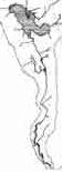
Surprisingly few people venture beyond the well-trodden path to the beach by the lake. The river which flows from Bogstad Water down to Oslo Fjord, provides, in addition to new swimming holes, a marvellous opportunity to experience the fascinating geography and the long history of the border between Oslo and the surrounding county of Akershus. The valley of the Lysaker river which flows just 7 kilometres from Bogstad to the fjord contains many reminders of early industrial Norway. Mills for grain and timber, iron-works and stamping mills for wool and powder have drawn their power from the stream since the Middle Ages.
The river in its steep valley has always been a barrier to east-west travel and as such has formed a natural administrative boundary. Today, vehicles can only cross the stream on the E18 motorway or its interchanges, or the two other major national roads Bærumsveien (RV 160) and Griniveien (RV 168). The main railway line to the south and west of Norway and two suburban light-rail lines cross the river close to these roads.
Pedestrians and cyclists have much greater flexibility. Eight bridges for foot and bicycle traffic make possible round trips along opposite banks varying in length from two to fifteen kilometres. The trails north from the business district at Lilleaker have been upgraded to an excellent all-weather standard.
BEFORE YOU START
This guide provides trail notes for the foot and cycle paths along each side of the river with notes on points of natural, historical or social interest for the visitor to Oslo. The guide starts at Bogstad Camping and works its way downstream along the major track (which begins on the left bank and crosses to the right after about 3 kilometres). The more difficult paths on the opposite bank are described for the walker moving upstream.
FOOTWEAR
If one plans to stick to the major path, ordinary rubber-soled shoes are adequate. When the ground is dry these will suffice for the minor tracks as well, but after rain the unsealed clay quickly becomes treacherously slippery and only heavily treaded soles will do. Ask locally before starting!
SKIING
In winter, the main path above Ullern mill occasionally has sufficient snow cover for cross-country skiing. It is gentle trail with just a couple of down-hill sections to test those who didn't learn to ski in kindergarten. It leads directly to Bogstad Golf Course which is a favourite training ground for beginners and a starting point for ski trails into Nordmarka and Bærumsmarka.
FITNESS
Whether moving upstream or downstream there are several steep climbs; in places, steps have been cut or timber stairs provided. It is easy to maintain a normal walking pace downstream, but allow twice as long when walking upstream. Bus routes along the major roads (Vækerøveien and Vollsveien) parallel to the river provide an alternative means of returning to your starting point.
How to get there
For campers at Bogstad just pull on your walking shoes and proceed to the south west corner of the camp ground. The trail notes begin at the intersection known as Peder Ankers Plass
From the city centre take the bus: no.32 (Voksen Skog) which departs from Oslo S and National Theatre, or 41 (Sørkedalen) from Røa T; alight at Bogstad camping and take the road down to the west past the bust of Peder Anker.
The middle sections of the river valley can be reached by taking the No.5 (Østerås) light rail (T-bane) from Storting or National Theatre as far as Ekraveien or the No.2 (Bekkestua)to Bjørnsletta. The no.13 blue tram (Jar) is a relaxing alternative to Øraker on the left bank or Jar on the right bank of the river. Lilleaker station on this line gives access to the old industrial area and to the falls at Granfoss and Jar.
For those interested in the lower reaches of the river with the homes of the renowned artists of the Lysaker school, a train to Lysaker or No. 32 bus to Lysakerbru is the best alternative. Be prepared, however, for the endless sidewalks in the concrete maze of the new business district.
BIBLIOGRAPHY
Books
Sigurd Senje's book "Naturens nectar" has been my major source for the history of the Lysaker Valley. It has some dubious opinions about geological and historical origins, but for those who read Norwegian, it can be found in the public libraries.
While I have drawn much information on the Geology of the Bærum caldera from Geology of Norway and Just Gjessing's work on moraines in Aker (Norsk Geografisk Tidsskrift), the popular guide.by Professor Johannes Dons "Oslo-traktenes geologi" (Vett & Viten, Oslo, 1996) is handy for those with a little Norwegian who wish to study the terrain more closely. But for a magnificent souvenir of Norway's amazing geology, the translation "The making of a land: geology of Norway" published by the Norwegian Geological Society (Norsk Geologisk Forening, 2008, kr. 495,-) contains several wonderfully illustrated chapters that set the scene. The definitive study of Lysakerelva's geology has, however, yet to be published.
For the flora and fauna of the valley, I have relied on my own observations and the "Natural History of the British Isles" to teach a native of the southern hemisphere about the strange species one finds so far north. Any books covering Northern Europe will do.
In 1997, Trygve Christensen published the results of his researches into the whole of the Sørkedal catchment with wonderful 'new' illustrative material including old maps and a painting of Ullern mill.
Two guidebooks in Norwegian contain reasonably good maps to follow the trails. The 3rd edition of Frithjof Funder's "40 trivelige turer i Oslo" (Vett & Viten, Oslo, 2008) and "Elvelangs: Turguide til elvene i Oslo" (Aschehoug, Oslo, 2004; available from LvV, NOK 150 plus p & p kr. 25,- to Norway, NOK 40 to Europe or NOK 75 to the rest of the world.)
Finally, LvV ditributes a list of historical events that have occurred along the river when ever we hold a course. It contains a more detailed list of references.
Maps
Oslo kommunes oppmålingsvesenet gave me access to the earliest detailed maps of Aker kommune. These were prepared between 1921 and 1935 on a scale of 1:1000. The sheet numbering follows the system employed until the GIS belatedly reached Oslo in 2005. Lysakerelva is covered by sheets G10-G8, F8-F4 and G4-G1 in the north-west (NV) quadrant and sheet F1 in the south-west (SV) quadrant. The quadrants have their origin at the old Observatory in Observatoriegaten behind the National Library at Solliplass.
Maps of the bedrock and quaternary geology have been published by Norges Geologiske Undersøkelse in two maps at a scale of 1:50 000 entitled Asker (1814 I)
The Municipalities of Oslo and Bærum have each published guide maps that cover the river trails. The Turveikart "Oslo vest" published by the Oslo parks authority in 2008 has finally drawn the path along the Oslo bank properly, but lacks any detail on the Bærum side; an example of the ridiculous management regime that exists when the county boundary follows the river! Bærum kommune has published a map edited in 1997 by Trygve Christensen, but the trail is somewhat inaccurate today especially around Bærumsveien..
Web links
Bærum library has a catalogue of early photos available for sale; click the uppermost magnifier to get their search protocol and use "Lysakerelva" as your search term.
Copyright © 1998-2013 John E. Tibballsstyret@lvv.no
Lysakerelva and I
Now, in 2013, it is 28 years since I came to live by Lysakerelva. Before that I had lived in Oslo for a total of five years and knew the area from Bogstad to Maridalen well from walking and ski trips and numerous training runs. I knew that Maridalen drained via Akerselva to Bjørvika, that Sognsvann drained through Frogner Park to Frognerkilen. Yet it had never occurred to me how Bogstad Water drained to the fjord. I, who had long been fascinated by maps, by geography as a subject at school and by geographically special places! (Why else choose Oslo for what was to be just one year of overseas study?)
When, in the gloom of an autumn evening, we inspected the house that was to become our home, it seemed all too small for a growing family of four. After the inspection, my reservations were countered by references to the garden which I had only glimpsed through a window. I resolved to carry out an unofficial inspection in daylight. With the estate agent's map in hand, I approached the house from the river side and was soon convinced; any lack of space inside would be outweighed by limitless access to a wilderness beyond the back fence.
The river had frozen solid the winter that we moved in. Early one week-day morning we were woken by a continuous rumbling. We had learnt that reverberations from old Fornebu airport carried far in foggy weather, or could the incessant noise of traffic two kilometres away on Drammen Road be so deafening? Had all that traffic been directed along the much closer Bærum Road? With the dawn came the realisation that the ice on the river was breaking up. The ice palaces from the falls had collapsed and were being rolled and smashed by the flood of melting snow. Almost at the bottom of the garden.
The wilderness became my training ground. My runs took me upstream in summer and autumn, and down the river especially in spring looking for ice-free paths along which to stretch out muscles that had adapted to the careful gait of the winter jogger. In those days I had literally only a passing interest in the piles of masonry that lay at intervals beside the river.
Age has slowed my running to a jog and my jogging to a walk. I now carry a camera and a notepad when I head down to the river. A measuring tape and a compass also find space in my bag when I clamber over the piles of rocks to measure up the plan of a ruin. How did the mills function and how did raw materials get in and the products out? The popular Norwegian books I found gave answers on the history of the area, but not about its geography, the natural context in which commerce and industry thrived until the needs of a growing populous decreed otherwise.
So I began to document what I saw, to seek out material in academic libraries and to observe the seasons. Having come from beyond northern Europe, a thrush was as new to me as a willow tit, a magpie as a pygmy owl? I have been driven by curiosity and an inner need to understand my new surroundings. Whether this booklet is your introduction to Lysakerelva or a "second opinion" to that which you have already formed, I hope it enlightens you as much as its writing has enlightened me.
The above is updated from the foreward to a little booklet written in 1994. Several events in the following years caused me to write short notes.
SPRING 1995
Winter, although milder than most, persisted almost to Easter and left some dramatic changes in the vegetation. First though, autumn storms before the ground froze solid uprooted many large conifers especially along the west bank of the river. Then early in the new year, falls of heavy damp snow bent and broke bushes and trees throughout the district. Large pines and spruces, undoubtedly survivors of the great storm of 1906, succumbed, cutting Wilse's Trail in several places. The teams of volunteers from Voll had much to repair and clear away.
AUTUMN 2000
The heavy rains that persisted right through October surprised everyone by filling the aquifers in the Silurian bedrock and overflowing as bubbling springs that sent new rivulets down to the river. Many gardens and basements experienced flooding and the trails have been made impassable for prams in a quite few places especially around Ullern Mill and Lysejordet.
WINTER 2009
Transferring these web pages to the Friends of the Lysaker Basin (LvV) web site has been an occasion to update these notes. The establishment of LvV and of Oslo Elveforum have lead to an increased focus on rivers in Oslo. The information noted here has helped officials become acquainted with the river and its surroundings so that a common understanding of the needs of a natural environment embedded in an urban landscape can be established. The effects of climatic changes have been especially apparent. Whereas one could write in 1995 that frosts could occur from mid September until mid May, today we are surprised by a frost before mid-October and disappointed by a frost in May that threatens spring plantings. An exciting new find coming out of all this attention has been a stone-age site with remains of flint working.
SPRING 2012
The shortest winter in living memory after two quite cold winters has seen all vestiges of snow gone by late March. Pollen before the equinox and trees and bushes budding mean that any surveying will need to be done by Easter by which time visibility among the hazel scrub will be lost.